Search My Blog

Showing posts with label Food and Travel. Show all posts

Friday, October 28, 2011

The Cold Northerly Winds - The Last Frontier of the Cold War


My visit to Korea was full of surprises (sprained knee included). I have included photos of my trip there in the gallery section of my blog, so you can have a look there. To cut a long short, I will first write about my visit to the de-militarized zone (DMZ). (By the way, the pictures you see here are not in chronological order. You can check out more photos under my photo gallery. You can access it via the navigation bar above.)

Panmunjom, the village near the DMZ, is located some 56 kilometers from Seoul.

The Cold War had always intrigued me. In fact, knowing full well of the potential danger that lies ahead of me, curiosity got the better of me, and after much thinking, I decided that it was somehow worth the risk, to embark on a once-in-a-lifetime journey to see the last frontier of the cold war.

Unifying a divided country. It takes two hands to clap


Just how risky you may ask? It depends. Firstly, the two Koreas are still at war, technically. Secondly, you may be asked to sign an indemnity form, to indemnify the United Nations Armistice Committee and the US Army against anything tragic that might happen (touch wood) to you, if you decide to visit Panmunjom and the United Nations Joint Security Area (JSA).

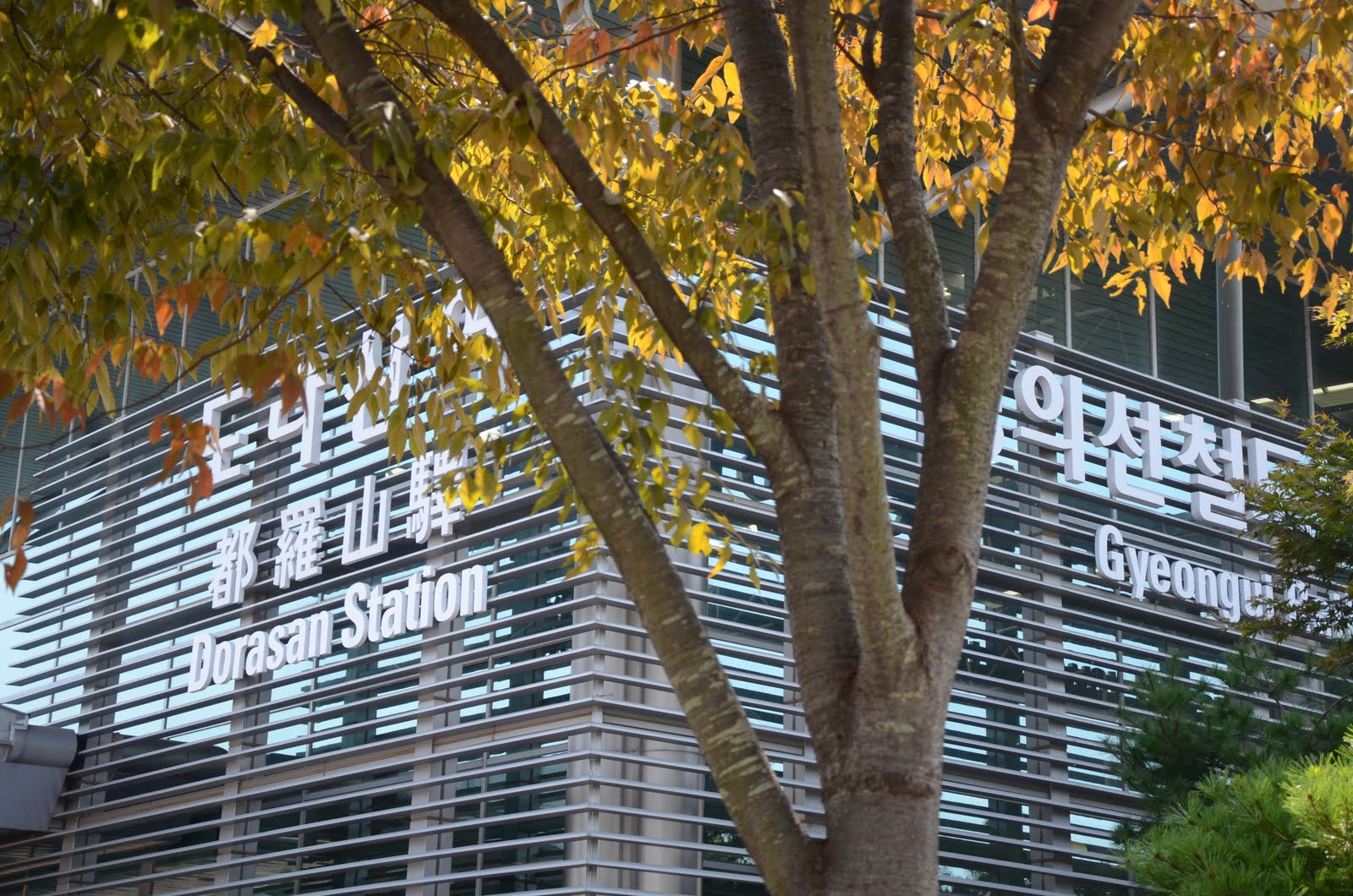
Mount Dora Station. The last station in South Korea, connecting to North Korea.


A visit to the DMZ is not complete without a tour guide, as a guide can be quite informative. What about going alone? Nope, getting about on your own is just not possible, due to the inherent danger that lurks ahead. Mines are scattered all over the place in the millions. Barbed wire fences, machine gun turrets. Anti-tank explosives. Well, you get the idea.

Prayers for a peaceful reunification of the two Koreas.


Sounds serious enough to deter you from ever visiting the place? It shouldn't. A visit to the DMZ is basically divided into two parts, depending on the tour you are following. The first part is the 'normal' tour, which takes you to several places of interest near the DMZ (more on that later). The second part, is the one you should prepare for in advance. The second part involves a visit right into the heart of the DMZ. Yes, right into the no-man's-land, the 4 kilometer wide buffer zone that separates the two Koreas. People were killed there before, so do behave yourself! The tour bus will stop at one of the checkpoints and an American GI will do a security check on everyone in the bus before you are allowed to disembark the bus and head for Camp Bonifas. The place is, at least from first impressions, quite tourist friendly, and you can't be faulted for thinking that the place is a tad bit too touristy to be a war zone, but the JSA authorities have done much to make you feel right at home over there. Nonetheless, the element of danger still lurks, and the threat of an invasion from the north is very real. You have been warned.


The JSA Visitor Center, Camp Bonifas.


If you do intend to actually get into the JSA, it is paramount that you prepare your passport. Be informed that citizens from Malaysia and Singapore, among other countries, will need to submit scan-outs of their passports at least one week in advance to the Panmunjom Tour Office at the Lotte Hotel near the Korea Tourism Organization office. The background check is necessary as this is a high-risk zone and I suppose you can't have someone with malicious intent going there to start an second Korean War. Jokes aside.


The Joint Security Area.

 The JSA area (as seen above) is the real deal. That white building you see up ahead from where the blue conference buildings stand is the Panmungak, the North Korean JSA office. You you observe carefully, there is this pesky North Korean officer scrutinizing us through his binoculars. Makes us look like museum exhibits or wild animals in cages. Sheesh...

Photography in the JSA is limited to certain areas as they can't afford to have photos of the site leak to the North Koreans which can prove to be strategically advantageous to them.

I could go on writing  but I think I'll stop here. I'll leave the rest for you to discover on your own.

Want to go to Pyongyang?

==== END ====


Sunday, May 9, 2010

Trip to Bako National Park

Having been jungle trekking in the past and scaling some of the not-so-tall hills and mountains of Sarawak, I had been thirsting for a similar adventure so I asked myself, “Why not go to Bako?”

 DSCN5547

We had been planning this trip for a long time, way too long, and before we knew it, all the hostels and lodging were all snapped up for the weekend, so we went for a day trip instead.

For those who don’t know much about Bako National Park, the national park is the oldest in the East Malaysian state of Sarawak and is located some 29 to 30 kilometers from Kuching (see picture below), the capital of Sarawak. My pals gathered at my place on early Saturday morning at around 6.30am before meeting up at Thompson Corner for a hearty breakfast of kolo mee to keep our energy levels high for the trip ahead. I had been gaining some weight for some time (extra 15 kilos the last time I checked, may be higher now) so this is the perfect moment to get in shape.

bako-np

Bako National Park is one of the nearest national parks to Kuching, and getting there by car or bus should be a no-brainer. The second phase of the journey however requires visitors to travel by boat.

DSCN5488

It is possible to charter a motorboat at the national park terminal at Kampung Bako and it costs RM 47.00 per boat per way, for 5 persons.

The boat trip was quite scenic as we were greeted by views of the kampungs and fishing boats of the fishing village along the way for the first 5 minutes of the boat journey, followed by several stretches of mangrove swamps.

DSCN5610

The boat trip was a lot shorter than I had initially thought. As we were nearing the park’s jetty, we spotted some of Bako’s top attractions; walls of sandstone and limestone, crafted by wind and water over thousands of years.

DSCN5593

This is of course, not without getting a spectacular view of Mount Santubong, which is said to resemble the profile of Rajah Brooke lying down. The photo below was taken from Teluk Assam, near the jetty. Legend has it that there was once a princess named Santubong, who was cursed and turned into a mountain.

DSCN5499

It is not difficult to get around the park as most areas are accessible via trails which are properly maintained. The elevated plank walk shown below allows visitors to have a good view of the mangrove swamps.

DSCN5492

*To be continued in Part 2

Saturday, January 2, 2010

After Four on One

Sorry, I couldn’t resist writing such an apparently misleading title, but I like how the numbers ‘four’ and ‘one’ come together.

The first day of the year had a rather unusual opening.

I woke up at 11.45pm, just in time for lunch.

It was also the day Leonard, my twin, was due to fly back to Penang after a week long holiday back here in Kuching. Was I sad that he had to leave so soon? Not at all, he’ll be back for Chinese New Year.

P1050015_brightened

P1050028_rotated

To kick off with the celebration, we had lunch at this new joint called ‘After Four’, a place known for its cozy atmosphere, good food (huge variety, they claim to have ‘more than a hundred’), free wireless internet, and of course, its distinctive orange-coloured theme, making After Four really stand out of the crowd.

Speaking about variety, you’ll be spoilt for choice the moment you flip through the menu. Unlike other food joints here in Kuching, which are either ‘too cheap or too expensive’, you’ll always get something here that is ‘just right’.

I had a bowl of Cantonese Noodles, which, for only RM 5.50, is indeed deserving of praise, due to it’s generous serving.


P1050020 Cantonese Noodles

The picture above doesn’t do justice to the actual size of the bowl. Aaron, on the other hand, had the Cantonese Rice in Basket (shown below).

P1050021

The Four ‘No’s

In church, we are often reminded of the Ten Commandments, but at After Four, you will see the ‘Four No’s’ prominently displayed on the outside. That comes as no surprise, as After Four has obviously set their sights on the Muslim market.

P1050016_cropped

Huh? What’s this?

P1050012_brightened

Haha, maybe they should have added a ‘No Cats and Dogs’ to their list of ‘no’s.

P1050007_cropped

===END===

Sunday, December 27, 2009

Now Everyone Can Eat, and Ride?

“Now Everyone Can Fly!” (Yeehaa!)

How right they are. It used to cost so much more to fly around the country, and even more to fly out of Malaysia.

Then came Air Asia, and the rest became history.

The coming of Air Asia solved the problem of air-travel, which for many Malaysians like me, was rather expensive at times.

Then came another company, that for obvious reasons, gave me an impression that it wants to help prepare us Malaysians for some kind of impending famine or something.

FoodBusAsia2

With the wordings ‘Food Asia’ so prominently emblazoned on the red awnings shown above, it’s hard not to imagine that we might soon witness the rise of Malaysia’s (and the world’s?) first ‘low-cost’ food eatery, right? Hmmm, let’s find out…

image

A quick look at their website (www.FoodAsia.net, duh!) reveals an assortment of mouth-watering delights, from our local Sarawakian Apam Balik to the not-so-local Philippines Mee Hoon. I think they’re quite right about the pricing though; you can get just about any dish for RM 4.00 and below, and dessert for RM 3.00 or less. Finally, a place to get some decent food without burning a hole in your wallet. “Now Everyone Can Eat!”

And if that wasn’t enough, wait till you see this…

BusAsiaPic

“Now Everyone Can Ride!”

===END===

Sunday, July 5, 2009

Shooting Spree at the Waterfront

On the 28th of May 2009, three suspicious-looking persons were seen walking up and down the Kuching waterfront shooting away at people, newspaper stands, hotdog vendors and even at little old ladies.

What were you thinking?

lumix_resized00018 The Kuching waterfront today

It was a great evening for a photo-shoot, so I packed up my photo gear, and with the company of my two ‘accomplices’ (my siblings actually…), each armed with a camera, we had a splendid time learning ‘real’ photography, which was nothing like shooting indiscriminately at all things around. The photos bearing this site’s watermark were captured using the Lumix DMC LX-3, unless otherwise specified. In this post, I promise you, there will be more pictures, and less talking, so happy viewing!

VBrookeKuching Kuching in the olden days


lumix_resized00004
The Tua Pek Kong temple

lumix_resized00005

The Kuching Hilton. In the foreground is the James Brooke Bistro.


lumix_resized00006

HarbourView Hotel, just behind the temple. To the right is the Cineplex building.


lumix_resized00008The Waterfront. To the left is Riverbank Suites, just opposite of Riverside Majestic and adjacent to Hotel Margherita.


lumix_resized00009

One of the numerous riverboat ‘taxis’ that will take you across the river for less than MYR 1.00 each way.


lumix_resized00020 Sarawak River Cruise with the new state legislative council building in the background.


lumix_resized00025Kuching CBD.


lumix_resized00039

I don’t know what this is, but it has been here for as long as I can remember…should check it out one day.


lumix_resized00046Observation tower at the waterfront.


lumix_resized00048

State legislative building seen from afar.


lumix_resized00056

The Astana, which was built in 1870 by the second white Rajah Charles Brooke, as a bridal gift for his wife.


nikon_resized00016 The Astana. This photo was taken with my Nikon Coolpix P5000.


lumix_resized00068Silhouette of river banks. Shot against the sunset. Seen here is the Sarawak River.


nikon_resized00035

The waterfront at dusk. Photo captured with the P5000.

 lumix_resized00049  The Old Courthouse of Kuching. A must-see for visitors and tourists.

_____________________________________________________________________________________

Thanks for viewing!

-Lionel Lam

===END===

Sunday, June 28, 2009

The Old Mines of Simunjan

resized00010 Road to Simunjan town centre.

On the 27th of June 2009, I had the privilege of travelling to Simunjan with my uncle. Simunjan is a small town located some 150 kilometers from Kuching, the capital of Sarawak state, East Malaysia. We left home at around 7.30am, had a hearty breakfast of kolo mee and wonton soup to prepare us for the long trip ahead. It was quite a long trip down the road, but the relatively new Kuching-Serian highway made possible to drive up to speeds of 120 kilometers per hour without winding up in a ditch. I regret not taking pictures of the trip to the town as it had been rather breathtaking and scenic, with lush greeneries and sago palms as well as durian trees lining the otherwise rather homogenous landscape.

simunjan2 Simunjan is a small town located South-East of Kuching.

resized00008 A typical Simunjan town house.

After several hours and stops later, at approximately 11.45am, we arrived at Simunjan town where my uncle hired a guide to take us up a neighboring mountain. This mountain is home to a coal mine that was set up by the British colonial government in the olden days and was taken over by the Japanese during their years of occupation of the state.

resized00013

We parked the car at the foot of the mountain. We had to wear long-sleeved shirts as we had no plans to feed the hungry and vicious mosquitoes. Our guide, Jusop, who hails from the town runs his own farm nearby, so he was quite familiar with the mines in the area. According to Jusop, the mines, which have long been abandoned, are so obscured from view that not many people, even from the town, know where to locate them.

The ascend, in my honest and humble opinion, was quite a challenge (it was fun, by the way), as I never did rank very high when it came to my own stamina and strength. But these trips to the countryside usually afford me the opportunity to see things that the average Joe in the city (or if you’d like to put it, any Tom, Dick and Harry) don’t usually see.

resized00016

Part of the ascend up the mountain involved climbing flights of rock ‘stairs’ which had been carved naturally by water flowing from the top of the mountain. In fact, if you were to take a closer look at the photo to the right, you’d notice remnants of miniature rock pools.

There is an old saying here that respect towards the jungle: wildlife, plants and the elements, constitutes respect towards the unseen spirits that are said to reside in the jungle. That being said, I was really careful not to step on the numerous centipedes that I saw along the way to the top. Perhaps I was just being paranoid.


resized00018

One of the many centipedes I saw along the way.

resized00019

At around noon, we reached the first mine entrance. As you can see in the picture to the left, Jusop was telling us a bit about the history of the mine. It is learnt that this is one of several entrances to a fairly elaborate network of tunnels. The year inscribed on the apex of the tunnel indicates the year the tunnel was built. Closer inspection of the tunnel interiors showed that the mine shaft had collapse and was no longer safe to enter. I wouldn’t be surprised there were mine workers entombed in these tunnels.


resized00023

resized00024


The picture to the left shows the collapsed portion of the tunnel, which is some 20 meters up ahead.

In about 20 minutes, we left the first tunnel for the second one, which was about another 30 minutes walk from the first one.

It was difficult to ascertain the age of the second tunnel (photo: below right) as unlike the first tunnel, there was no inscription found on this tunnel. The second tunnel opening was square-shaped and we believed it to be older than the first one, judging by the size of the opening and the condition of the walls.


According to the guide, there was an elaborate network of rails which were used to transport the coal to the base of the mountain. Obviously, the rails were not visible at first glance as the floor had become so dense with undergrowth (photo: below left).

resized00047

resized00031


Photo to left: The forest floor had become overgrown with vegetation that it was nearly impossible to tell where the rails led to.


resized00039 My uncle taking a reading from a GPS device. To his right was Jusop, our guide.

resized00042

My brother Aaron, standing by a well built by the Japanese.

resized00045

The well up close.

A Closer Look at Nature

We decided that there was nothing else to do after seeing the second tunnel so we prepared for descent, but not without taking a few quick shots of what mother nature has to offer.

resized00049 Bracket fungi growing on living tree.

resized00051Bracket fungi growing on living tree (near the well and 2nd tunnel).

We reached the base of the mountain at around 1pm. My feet were numb, I was dreadfully thirst, and of course, hungry.

resized00057

A village road. Notice the farmhouse to the left.

So we headed to Simunjan town center for lunch.

resized00065 Food court at Simunjan town.

It was only around 1.20pm when we arrived at the food court, and it was really deserted. A funny thing that we didn’t fail to notice was the manner which the stalls were arranged; drinks stalls and food stalls were arranged alternately. Perhaps most amusing was the fact that there actually was a Hilton at Simunjan. But it pays to have an open mind….

resized00064 I told you I wasn’t lying when I said there’s a Hilton there in Simunjan…High tea at Hilton anyone?

The food there was not too bad either. I can honestly say, in all my years of eating out, I rarely can find a food outlet that serves soup as good as this one (pictured below). In stark contrast, the soup at All Joy Good Food in Kuching tasted like salted dishwater.

resized00067

resized00068

The heart of Simunjan town.

resized00069

100% Discount Store at Simunjan town center.

resized00070 Simunjan fire station.

resized00071Saying our goodbyes to Simunjan as we headed back to Kuching.

resized00074 British-built steam engine.

On the way back to Kuching, we came across an old steam engine which was located by the Simunjan road. It’s real purpose? It’s been keeping us guessing until now.

resized00086

The Kuching-Serian Highway on the way back home.

resized00089After a tiring day, it’s good to be back home.


A Little Lesson On History…

According to my uncle, the history of the mines could be traced back to the year 1872, or possibly earlier, during the era of the first white rajah of Sarawak, James Brooke.

An excerpt from an email from my uncle best describes the scenarios in the old days:

“As I stood in front of those two mines (dated 1912  or earlier), I needed some moments of total peace and silence to try to capture all that had happened around there over  some 40-50 years.  I could see a  few of the English men leading the natives clearing the land, leveling the hills, digging the tunnels into the hills with spade and changkols, then hauling the iron rails up the hills, then years of crawling and digging, all the sweat and pain, how many died from accidents, sickness and diseases.  In the early years some buffaloes were used to haul the coal but his was later replaced by steam locomotives.  As we stood there,  the two tunnels bear testimony of the nameless people who had given their efforts to produce the 1 million  tons of coal from 1874 to 1931.  May be this was the reason why  the local people wanted to close the chapter of this history and they  do not want to hear the stories anymore! As I stood in front of those two mines (dated 1912  or earlier), I needed some moments of total peace and silence to try to capture all that had happened around there over  some 40-50 years.  I could see a  few of the English men leading the natives clearing the land, leveling the hills, digging the tunnels into the hills with spade and changkols, then hauling the iron rails up the hills, then years of crawling and digging, all the sweat and pain, how many died from accidents, sickness and diseases.  In the early years some buffaloes were used to haul the coal but his was later replaced by steam locomotives.  As we stood there,  the two tunnels bear testimony of the nameless people who had given their efforts to produce the 1 million  tons of coal from 1874 to 1931.  May be this was the reason why  the local people wanted to close the chapter of this history and they  do not want to hear the stories anymore!”

Yes, it was 1 million tons of coal extracted from those mines in those years. Why then were the mines closed down in the year 1932? One reason for the closure was the switching from coal to oil as an energy source of ships and power stations. The demand of gold from the Bau gold mines also waned in those year, and so did the demand of coal.

According to old records, the mines were mostly managed by Englishmen, among them was one Brooketon who was in charge of the mines from 1910 to 1931, until the mines closed. The mines were resurrected by the Japanese during their occupation of the state, and they somehow managed to extract some additional 3000 tons of coal from the miles of tunnels deep within.

I have personally seen the records of the mines, containing even the tonnage of the coal yield. The records from the geological department showed even the minutest of detail, right up to the thousands of tons extracted every year until the mines closed in 1932. My uncle even remarked that the English have been known to possess an impeccable sense of observation, and keenness towards their surroundings, and this is evident in the works of famous naturalist Russell Wallace, who in 1855, spent a few months collecting as many as 2000 species of beetles in Simunjan!

If the Chinese had gotten there before the British, the beetles would have become a staple diet of the local folk, he joked.

The trip to Simunjan had been well worth the effort, as it was an eye-opening experience. I saw what many people never saw, had experienced what many never experienced, and learned what many would never learn. I hope whatever I have written here would give you a glimpse of the history of our magnificent state. Long live Sarawak!

-Lionel Lam.

===END===